MODELOS CORTICALES EN LA ZONA CENTRO SUR DE LOS ANDES DE MÉRIDA MEDIANTE UN ESTUDIO DE SÍSMICA PROFUNDA CRUSTAL MODELS IN THE CENTRAL-SOUTH AREA OF THE MERIDA ANDES USING DEEP SEISMIC DATA
Autores:
Fundación Venezolana de
Investigaciones Sismológicas
Fundación Venezolana de Investigaciones
Sismológicas
RESUMEN
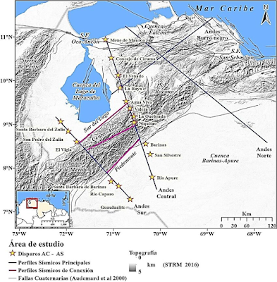
En el marco del proyecto de Geociencia Integral de Los Andes de Mérida (GIAME), se realizaron investigaciones geofísicas y geológicas integradas, dentro de las cuales se encuentra la elaboración de modelos corticales de ondas P mediante la adquisición, procesamiento y análisis de datos de sísmica profunda. Se estudiaron tres perfiles denominados Sur del Lago, Centro Andes y Piedemonte, los cuales se ubican paralelos al eje axial de la cadena montañosa. Se elaboraron modelos 2D de velocidades con los cuales se pudo estimar tanto el espesor como las velocidades promedio de las principales estructuras interpretadas (sedimentos, corteza superior y corteza inferior). Considerando las profundidades de Moho, se realizó un mapa de espesores corticales para determinar su variación lateral. La profundidad cortical máxima fue de 52 km. La distribución espacial de los espesores corticales indican un desplazamiento de la raíz de Los Andes de Mérida de aproximadamente 40 km, al noroeste del eje axial de la cadena montañosa, lo que podría implicar un contexto tectónico formacional asimétrico.
ABSTRACT
Within the framework of the Integrated Geoscience Project of the Merida Andes (GIAME), multidisciplinary geophysical and geological investigations are carried out, which include the development of P-wave crustal models through the acquisition, processing and analysis of deep seismic data. Three profiles called "Sur del Lago", "Centro Andes" and "Piedemonte" were studied, which are located parallel to the axis of the mountain chain. 2D velocity models were developed with which both thickness and average velocities of the main interpreted structures (sediments, upper crust and lower crust) could be estimated. Considering the depths of Moho, a map of crustal thicknesses was made to determine its lateral variation. The maximum crustal depth was 52 km. The spatial distribution of crustal thickness indicates a displacement of the mountain root of approximately 40 km, towards northwest of the axis of the mountain range, which could imply an asymmetric formation of the Mérida Andes.
ARTICULO COMPLETO DISPONIBLE EN:


Comentarios
Publicar un comentario